Mesas do Castelinho
Mesas do Castelinho is an archaeological site listed as a Property of Public Interest (Imóvel de Interesse Público), about 2 km from the village of Santa Clara-a-Nova, in the Almodôvar municipality. It is an Iron Age settlement, founded in the late 5th to early 4th century BC beside the Ribeira de Mora stream, on the frontier between plain and serra in the upper Mira valley. It covers three and a half to four hectares, was continuously occupied until the early 2nd century AD and, much later, housed a rural Islamic fortification. It is the main archaeological attraction of Santa Clara-a-Nova and, in the words of the Almodôvar municipality's visitor circuit, "one of the most important archaeological sites in southern Portugal".
Where the content of this page comes from
Everything stated here comes from the research published by the team that excavated the site between 1988 and 2018, and from the state fieldwork register. Where the sources diverge, as on the foundation date, the wall or the end of the Islamic occupation, this page uses the wording none of them contradicts, and the evidence register shows why, with sources and page numbers.
How we know what we showHistory
From an Iron Age walled village to a small Islamic castle
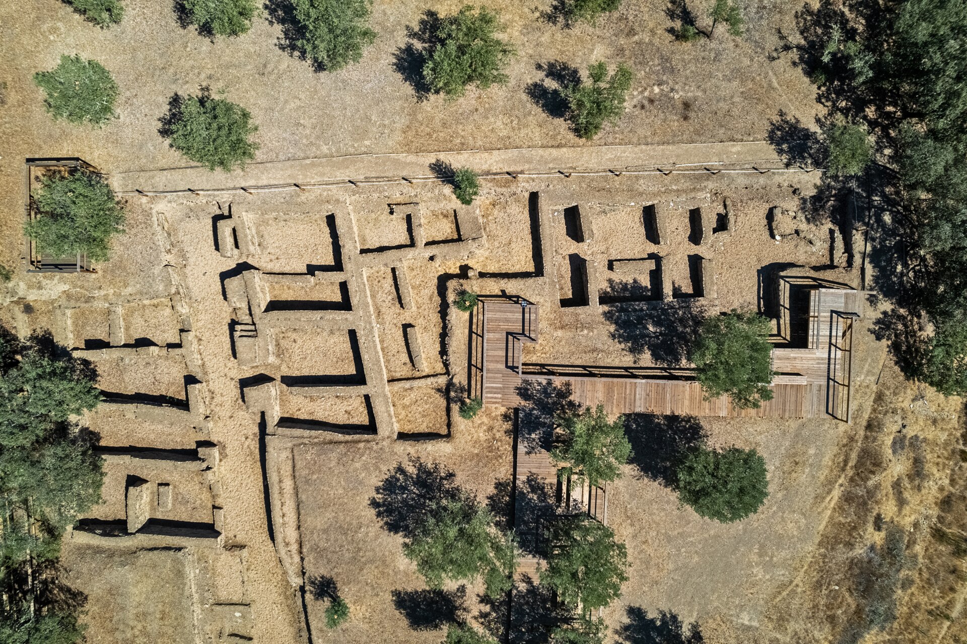
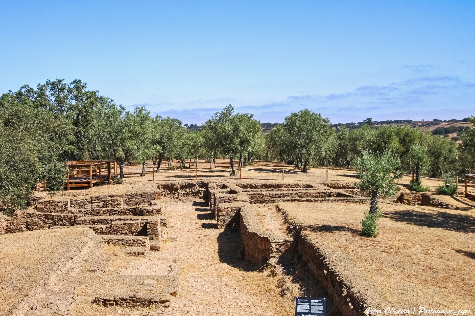
The site sits on two flattened platforms at the top of a hill: Platform A, rounded and higher, and Platform B, trapezoidal and lower, covering three and a half to four hectares in total. That table-like shape is where the name "Mesas" (tables) comes from. The "Castelinho" (little castle) came much later, with the medieval Islamic fortification. The chronology below is the one established by the archaeologists who have excavated the site since the 1980s: Carlos Fabião and Amílcar Guerra, of the University of Lisbon (UNIARQ), and Susana Estrela, who studied the foundation levels.
Foundation: late 5th to first half of the 4th century BC
The settlement was founded in the late 5th to early 4th century BC, in the Second Iron Age, on a natural route for the movement of people and goods and on ground with no earlier occupation, a "foundation from scratch", in the excavators' words. In this earliest phase (Phase III, in Estrela's numbering) the upper platform saw a moment of post-built huts and hearths before the fortification was built: the settlement begins without a wall. Whether the wall still belongs to the founding phase or to a later moment is a question the excavators themselves call stratigraphically undecidable, and both readings are set side by side in the evidence register. Estrela reads it, in any case, not as a defensive line but as "a mark in the landscape, a point of reference, rather than a place meant to be impregnable".
Continuity: second half of the 4th to the late 3rd century BC
The settlement remained occupied without interruption throughout this period, continuing the founding phase. Much of the daily life of this phase is still literally underground: the estimate that only about 10% of the site has been excavated is Carlos Fabião's, quoted in the press, not a published measurement.
Final Iron Age phase: 2nd century BC
The last Iron Age phase, in the 2nd century BC, was restricted to Platform B. In this period the settlement shows some of the earliest known contacts with the Roman world anywhere in the region. The wall was no longer in use: in the Roman levels Estrela records "the total absence of the walled circuit", with Republican compartments sitting on top of it. At no point is there a destruction horizon: "without breaks or destruction levels".
Roman period: 2nd century BC to the early 2nd century AD
In the Roman Republican period, between the end of the 2nd century and the first quarter of the 1st century BC, the settlement was given a careful orthogonal plan, with three north-south streets and blocks, as if preparing to become a town. The upper platform, which occupation had withdrawn from in the 2nd century BC, was built on again: the municipality's visitor circuit places a Roman residential area of the 1st century BC up there, with ovens against the houses and a drainage structure, reusing Iron Age constructions, and gives it as abandoned in the middle of that century, before, therefore, the abandonment of the settlement as a whole. Under Augustus the programme reverses: the streets are blocked, the large houses subdivided into small compartments, and the upper platform apparently goes out of use. Abandonment comes in the early 2nd century AD, gradually. The full story of this "failed urbanism", and the explanation the excavators give for it, is told below.
Islamic fortification: 9th to 11th centuries
After some seven hundred years with almost no occupation, the hilltop was occupied again by a rural fortification of the Umayyad period, with a settlement beside it on the lower platform, active between the 9th and 11th centuries. That little fort is the origin of the name "Castelinho". The three radiocarbon dates from the castle ditch are too wide to decide the question, and the authors call them "of little use": it is the ceramics that fix the range: Emiral and Caliphal forms present, Almohad forms absent.
Failed urbanism
The town the Roman road forgot
Archaeologists Amílcar Guerra and Carlos Fabião describe Mesas do Castelinho as an example of "failed urbanism" in southern Lusitania (Guerra and Fabião, 2010). In the Roman Republican period, between the end of the 2nd century and the early 1st century BC, the settlement was given a careful orthogonal plan, with three north-south streets and the regular layout you would expect of a future Roman town.
Except the town never came to be, and the excavators themselves refuse the word: "the absence of any sign of public architecture prevents us from considering this settlement a town". The explanation they give for the abandonment is their own interpretation, argued from the Roman itineraries and not independently documented: the Augustan creation of Lusitania, Pax Iulia as the legal seat 70 km away, the pull of the Augustan mines, a road network that bypassed the Caldeirão pass and, above all, the choice of Arandis, probably Garvão, as seat of the civitas. Off the roads, off the map: Mesas do Castelinho was abandoned in the early 2nd century AD, after more than half a millennium of continuous occupation.
It is a 2,000-year-old lesson about the power of infrastructure: whoever is left off the network disappears. Few places tell it as clearly as this hill in the Baixo Alentejo.
The Islamic Castelinho
A rural fortification between the 9th and 11th centuries
After a long abandonment, the site was occupied again in the Islamic period. Between the 9th and 11th centuries a rural fortification of the Umayyad period operated here, with a settlement beside it on the lower platform, probably linked to territorial control during Muslim rule. From 983 identified bones the excavators conclude that there was no domestic pig and that hunting weighed heavily, and so that these were "not fortified peasants but a group with eminently warlike functions": a garrison placed by an external power. This small fort is the origin of the name "Castelinho" (little castle).
Destruction, discovery and research
From 1986 to today: the site's scientific career
The destruction of the site was not one episode but three. In the late 1950s the then landowner levelled the upper platform, destroying most of the interior of the Islamic fortification. In the 1960s, the earthworks for planting the olive grove that still covers the lower platform disturbed the layers above the Roman levels. And in late 1986 a machine worked the hill for more than two weeks in search of treasure, opening a cut over five metres high in Platform B. About a third of the site was destroyed. The Almodôvar municipality attributes the 1986 destruction to treasure hunters chasing the riches of the Lizard-Man legend; treasure-hunting on the hill, though, has a "long history" already on record in 1960.
It was a heritage disaster, but it had an unexpected consequence: it launched the monument's scientific career. The 1986 destruction triggered salvage excavations led by Carlos Jorge Ferreira (IPPC). In 1988, Carlos Fabião and Amílcar Guerra, of the University of Lisbon (UNIARQ), were invited to take over the research, and systematic campaigns ran from 1989, with Susana Estrela as co-coordinator from 2006. In 1990, Mesas do Castelinho was listed as a Property of Public Interest (Decree no. 29/90, DR I Série no. 163, of 17 July 1990).
Excavation ended with Sector A4 in September 2018, after eight sectors had been opened; in June 2022 there was a further non-invasive ground-penetrating radar survey and a campaign listed that summer, under the name PROMECA. The finds include a stela bearing the Southwest Script, spotted at the end of the 2007 campaign in Rua 1 of Sector B3 and lifted in September 2008. It had been reused face down in a fill preparing the circulation surface of the street, some three centuries younger than the inscription itself. And a terracotta human head, found in 1995 in Sector A1 in secondary position, which the only archaeologist to publish on it reads as "a toy, or even a decorative object", on display in the village museum. Archaeobotany is among the site's strongest evidence: barley is the most ubiquitous crop in every phase, on soils already impoverished by the 4th century BC. And a pit from the start of the Republican occupation yielded ninety fig seeds, with two broken vessels that refit and an iron object, a deposit that, in the authors' own hedged wording, "porventura", perhaps, marked the inaugural moment of that space, rather than a meal.
Explore further
Two stories born on this hill
The Southwest Script
The oldest writing in the Iberian Peninsula remains undeciphered. Meet the stela found at Mesas do Castelinho in 2008 and the museum dedicated to the script in Almodôvar.
Discover the scriptThe Lizard-Man Legend
An enchanted house, a guardian half man, half lizard, and a treasure that vanished with the sign of the cross. The legend that accidentally launched the site's archaeology.
Read the legendHow we know what we show
The evidence register: sources with page numbers, what is attested and what is inferred, the points where specialists disagree, and the gaps nobody has filled.
See the evidence registerManuel Vicente Guerreiro Museum
The ideal starting point, in the centre of the village
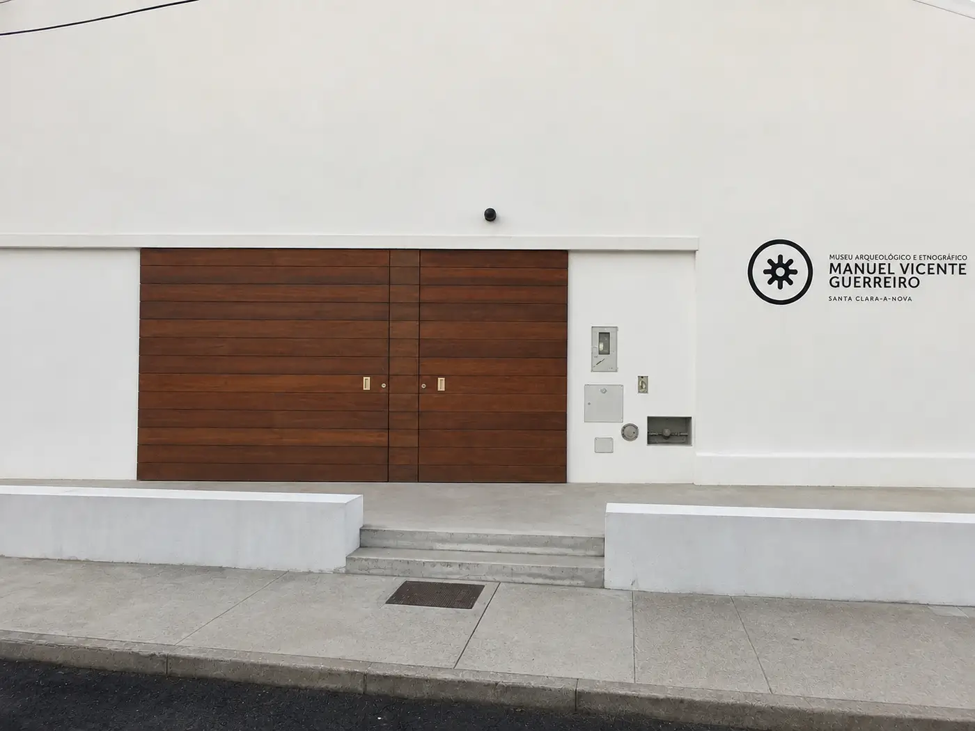
The Manuel Vicente Guerreiro Archaeological and Ethnographic Museum opened in 2015 in the village of Santa Clara-a-Nova (Rua da Estrada Municipal 29). It has a space entirely dedicated to archaeology, displaying part of the finds recovered at Mesas do Castelinho, and an ethnographic collection on rural life, trades and tools of the plain and the serra. It is the ideal starting point for a visit to the archaeological site. Contact via the Almodôvar Town Hall: +351 286 660 600.
Visitor information
How to get there and what to know before visiting
| Location | About 2 km from Santa Clara-a-Nova, Almodôvar municipality |
| Admission | Free access to the exterior |
| Suggested duration | 1 to 2 hours (archaeological site), plus 1 hour for the museum |
| Accessibility | Walkways for reduced mobility (visitor circuit built between 2020 and 2023) |
| Languages | Portuguese, English, French and Spanish (QR codes on site) |
| Contact | Almodôvar Town Hall: +351 286 660 600 |
Visit in 360° with a guide
Before you come, or if you cannot travel to the site, walk Mesas do Castelinho in 360° from three points on the walkway, with a virtual guide who tells the story of the site. Free, in the browser.
Virtual visit of Mesas do CastelinhoHow to get there
From Santa Clara-a-Nova, the site is about 2 km away, with signposted access (about 5 minutes by car). From Almodôvar, take the EN2 towards Santa Clara-a-Nova (about 15 km) and then follow the signs. From Beja, take the A2 to Almodôvar (about 70 km) and continue to Santa Clara-a-Nova.
Tips for your visit
- •Comfortable footwear recommended for the terrain
- •Bring water and sun protection, especially in summer
- •Start at the Manuel Vicente Guerreiro Museum for historical context
- •Audio guides available for group visits (book in advance)
- •QR codes on site for self-guided visits in four languages
- •Combine with a visit to MESA in Almodôvar (15 km)
- •In summer, avoid the hottest hours (12:00 to 17:00)
- •Exceptional panoramic views at sunrise and sunset
Suggested itinerary (1 day)
Morning: visit the Manuel Vicente Guerreiro Museum in Santa Clara-a-Nova (1 hour), then drive to Mesas do Castelinho (2 km, 5 minutes) and tour the archaeological site with an audio guide or QR codes (1 to 2 hours). Afternoon: lunch in Santa Clara-a-Nova, then drive to MESA in Almodôvar (15 km, 20 minutes) and visit the museum and the historic centre (1 to 2 hours). A full day of archaeological heritage.
Frequently asked questions
Answers to the most common questions about Mesas do Castelinho
What is Mesas do Castelinho?
It is an archaeological site listed as a Property of Public Interest, about 2 km from Santa Clara-a-Nova, in the Almodôvar municipality, Baixo Alentejo, Portugal. A settlement of three and a half to four hectares, founded in the late 5th to early 4th century BC, continuously occupied until the early 2nd century AD and, later, home to a rural Islamic fortification between the 9th and 11th centuries.
When was the settlement founded?
In the late 5th to early 4th century BC, in the Second Iron Age. The team that excavates the site (Carlos Fabião and Amílcar Guerra, of the University of Lisbon, and Susana Estrela) writes both ends of that range in different publications, so the range is the honest way to state it. The dating rests on Attic Castulo cups and Gaditan amphorae; there are no radiocarbon dates for this moment. It was born on a natural route for the movement of people and goods, on ground with no earlier occupation.
Why was the settlement abandoned?
On the excavators' interpretation, because the Roman reorganisation of the territory left it out: the Augustan creation of Lusitania, a new road network that bypassed the Caldeirão pass, and the choice of Arandis, probably Garvão, as seat of the civitas. It is a reading argued from the Roman itineraries, not an independently documented fact. Despite a careful orthogonal plan from the Republican period, the settlement never became a town and was abandoned in the early 2nd century AD. Guerra and Fabião (2010) call it an example of "failed urbanism" in southern Lusitania.
Where do the names "Mesas" and "Castelinho" come from?
"Mesas" (tables) comes from the two flattened platforms that form the site, Platform A (rounded, upper) and Platform B (trapezoidal, lower), covering three and a half to four hectares in total. "Castelinho" (little castle) comes from the rural Islamic fortification that occupied the hilltop between the 9th and 11th centuries.
How do I get to Mesas do Castelinho?
The site is about 2 km from Santa Clara-a-Nova, with signposted access (about 5 minutes by car). From Almodôvar it is about 15 km. From Beja, take the A2 to Almodôvar (about 70 km) and continue to Santa Clara-a-Nova.
Is the site accessible for people with reduced mobility?
Yes. The visitor circuit, with walkways accessible to people with reduced mobility, was built between 2020 and 2023. There are also audio guides for group visits and QR codes for self-guided visits, with information in Portuguese, English, French and Spanish. Access to the exterior of the site is free.
How long does a visit take?
Between 1 and 2 hours for the archaeological site. It is worth starting at the Manuel Vicente Guerreiro Museum in the village (about 1 hour) and, for a full-day programme, adding MESA in Almodôvar (15 km).
How much of the site has been excavated?
About 10%, on Carlos Fabião's own estimate quoted in the press; the director's figure, not a published measurement. Excavation ran between 1988 and 2018 across eight sectors, and in June 2022 there was a further ground-penetrating radar survey. Most of the story is still underground.
What is the legend associated with Mesas do Castelinho?
The Lizard-Man legend: an old woman enters an enchanted house full of riches, guarded by a creature half man, half lizard, on the condition that she never invoke God's name. When she makes the sign of the cross, everything vanishes. The Lizard-Man is said to still guard the site. Treasure hunters inspired by this legend are blamed by the Almodôvar municipality for the destruction of 1986.
How do we know what this page says?
Everything stated here comes from the research published by the team that excavated the site, and from the state fieldwork register. The page "How we know what we show" gathers the evidence register: sources with page numbers, what is attested and what is inferred, the points where specialists disagree, and the gaps nobody has filled. The excavation team has not reviewed that register.